MOSQUITO CREEK AT RIVER ROAD
Spring: ** Summer: * Fall: * Winter: *
Independent Directions to this Site: From Highway 417 (The Queensway) take exit 121A (Bronson Avenue). Go SSE on Bronson for 3.6 km, crossing the Rideau River on the Dunbar Bridge and going over Riverside Drive, before bearing right to take the Brookfield Road exit. In 0.1 km merge right onto Brookfield Road and drive 0.5 km to Riverside Drive. Turn left onto Riverside Drive and go 6.0 km to where it becomes River Road. Then continue straight or south along River for an additional 2.9 km to the Mosquito Creek bridge, 0.2 km north of Leitrim Road. This is the beginning of the Mosquito Creek area.
Rideau River East Side Route Directions: From where you have parked along the dirt road at the Airport Gravel Pit & Cottage Road area, return to Riverside Drive. Turn right or south on it and proceed 1.1 km to where it becomes River Road. Then continue straight or south along River for an additional 2.9 km to the Mosquito Creek bridge, 0.2 km north of Leitrim Road. This is the beginning of the Mosquito Creek area.
Site Description and Birding Information: Mosquito Creek, which crosses into the Rideau River just north of Leitrim Road, used to be much more productive before the city bulldozed its way over these parts. However, the creek and its tributary which runs along River Road are still worth checking. There is a small area of riparian habitat adjacent the bridge itself. The gullies on either side of Leitrim often have ducks and geese in spring.
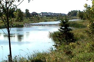
There are cattail-lined stormwater overflow ponds on the opposite side of River Road from Honey Gables. These are fairly new and don't yet attract much, but as they mature, they may become more productive. A Great Egret stopped here in May 26-28, 2007.
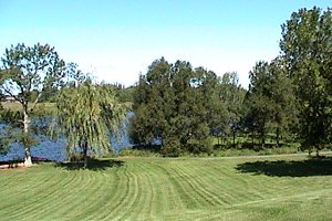
Nearby, only 100 m into Ryeburn Drive in Honey Gables is Honey Gables Park. This is a postage stamp sized green space along the Rideau River. It has a number of large deciduous trees lining the shore. These may attract migrants in season. The board expanses of lawn make it especially attractive to insectivores.
 Stormwater Overflow Ponds opposite Honey Gables
|
 View of Honey Gables Park
|
Rideau River East Side Route Directions: From the Mosquito Creek bridge go south on River Road 2.6 km, or from Ryeburn Drive 1.5 km, to the turnoff, on the right or west, for the next site on this route, Claudette Cain Park (formerly Waterfront Park). Park in the ample parking area.
Return to Rideau River East Side.
Return to Birding Ottawa Table of Contents.
|
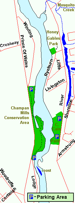 Map of the Mosquito Creek area
|