
(to view the satellite image of the area move your cursor over the map) |
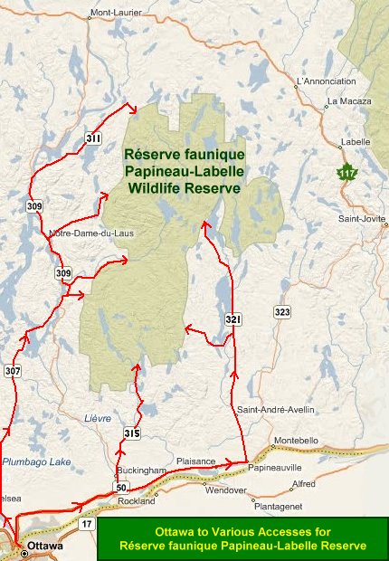
Independent Directions to this Site: To the southern access point off Autoroute 50 proceed as follows: From Ottawa take the MacDonald-Cartier Bridge to Hull and Highway 5. Follow Highway 5 for 1.3 km to exit 2. Bear right onto Autoroute 50 (Autoroute Maurice-Richard) and follow it for 31 km to the Buckingham/Masson exit at Highway 309. Loop around 180 degrees in 0.6 km on the exit ramp to the right, coming out on 309. Turn right or north toward Buckingham and drive 4.6 km into town and Highway 315 (Rue Joseph). Turn right or NE onto 315 and proceed 22.6 km to Chemin Smallian at the community of Blanche. Go c. 10 along this road to reach the reserve and reserve Route 1. To the eastern access points off Route 321 proceed as follows: From Ottawa take the MacDonald-Cartier Bridge to Hull and Highway 5. Follow Highway 5 for 1.3 km to exit 2. Bear right onto Autoroute 50 (Autoroute Maurice-Richard) and follow it for 31 km to the Buckingham/Masson exit at Highway 309. Loop around 180 degrees in 0.6 km on the exit ramp to the right, coming out on 309. Turn left or south and drive 0.6 km to Highway 148. Turn left or east onto 148 and follow 15.8 km to Highway 317 in Thurso. Turn left or north onto 317 and drive 35.0 km to Highway 321. Turn left or north onto 321 and proceed 7.7 km to Highway 315 at Chénéville and the first of two eastern accesses, reserve Routes 3 and 2. Follow 321 a further 18.5 km to its end for the second access point, the Mont Delvin area. For the first access: from Chénéville take Highway 315 west 7.8 km to the turnoff on the right for the reserve. Turn right and follow this road 12.3 km to the reserve and reserve Route 3, and in c. 5 km on the left, reserve Route 2. By the second access point, reached from the extension of Highway 321, it is 12.8 km beyond the 18.5 from Chénéville (total of 31.3 km) to the reserve and reserve Routes 6, 4 and 3. Site Description and Birding Information: The Papineau-Labelle Wildlife Reserve (Réserve faunique de Papineau-Labelle) is 40 to 115 km NE of Ottawa, as the crow flies; but will take 1 to 3 hours to drive to, depending on your choice of access points. It was set aside in 1971 mainly as a hunting and fishing preserve, with camping. It is heavily used for these purposes, although canoeing, skiing and even wildlife viewing are becoming more acceptable these days. It consists of 1628 square kilometres of mixed forest (all previously cut), dominated by sugar maple and yellow birch stands. There are an abundance of lakes (763) and streams and rivers (42) in the reserve. Nearly 20 species of wood warblers nest in the reserve, including Tennessee, Cape May, Magnolia, Blackburnian and Canada Warblers and Northern Parula. Olive-sided and Yellow-bellied Flycatchers also breed here, as do Black-backed Woodpecker and Rusty Blackbird. In winter, both Bald and Golden Eagles may be found. The hiking trail to the top of Mont Devlin, off Route 3 just south of its junction with Route 6, provides a panoramic view of that area and a good viewing spot for birds of prey. For an internet link to obtain more information, click here. |