Independent Directions to this Site: From Boulevard des Allumettières or Highway 148, take the Chemin Eardley exit in Aylmer. Turn right or northwest onto Chemin Eardley or the continuation of Highway 148 and proceed 28.5 km northwest on 148 to Chemin Cochrane. Turn left or south onto Cochrane.
Ottawa River West: Quebec Route Directions: In Eardley, from the junction of Highway 148 and the Ramsey Lake Road, a.k.a. Chemin Eardley-Masham, continue west on 148 for 2.1 km to Chemin Cochrane. Turn left or south onto Cochrane.
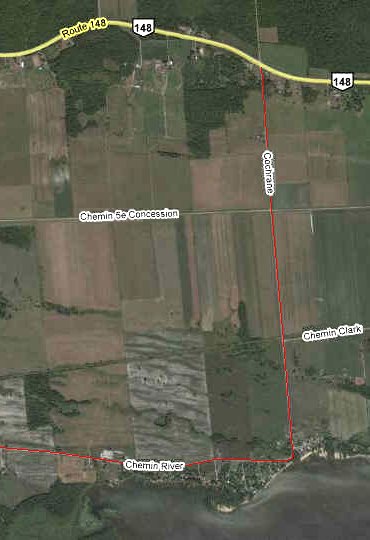
Site Description and Birding Information: This "site" consists of Chemin Cochrane and Chemin River (de la Rivière) and is basically a loop south of Highway 148 on dirt roads through a variety of habitats. Along Cochrane (first part paved) you will find agricultural land for the first 1.8 km (Bobolink, Eastern Meadowlark, Savannah Sparrow, etc.). At 1.8 km, the old rail bed crosses Cochrane just before reaching Chemin Clark, allowing access on foot through the adjacent area. Between 200 to 400 meters west of Cochrane on the old railbed, you will reach a wooded gully with standing dead trees. The same gully crosses Cochrane 2 km from Highway 148. After 2.6 km Cochrane reaches the Ottawa River and we will turn right or west on Chemin de la Rivière or Chemin River or River Road, depending on whose map or road signs you chose to believe. Views of the river are possible, but somewhat limited. There are several cottage access lanes left or south off the first kilometre of de la Rivière/River which may allow better views.
A Northern Hawk Owl was seen around 4130 Chemin de la Rivière, near the corner of Chemin Royal, from January 16 to at least February 9, 2002.
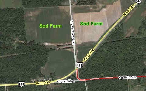
The road then veers away from the river and becomes very dusty as it passes through mixed woodlands and alvar-like areas. At 5.4 km along de la Rivière it becomes Chemin River or River Road on the signs and in 0.5 km it returns to Highway 148. Across from the junction there are fields of a turf farm, always a good spot to check for upland shorebirds in migration. A Buff-breasted Sandpiper was seen here on Sept. 6-10, 2010. And on Oct. 12, 2010 a female McGown's Longspur was reported from this location.
Ottawa River West: Quebec Route Directions: From the junction of Highway 148 and Chemin River Road, a.k.a. Chemin de la Rivière, turn left or west on 148. Proceed 2.6 km to Chemin Murray. Turn left or south on it and go 0.6 km to Chemin Mackechnie. Turn right or west and drive 0.6 km to Rue Onslow. Turn left or south on it and 0.4 km to the ferry dock at Quyon, the next site on this route.