HULL to VAL TÉTREAU
Spring: ** Summer: ** Fall: ** Winter: *
Independent Directions to this Site: From where Autoroute l'Outaouais or Highway 50 crosses over Autoroute de la Gatineau or Highway 5, the two major roads converging on Hull, continue on Hwy 50 south 1.3 km to Rue Montcalm. Turn left or southwest on Montcalm and follow it for 0.8 km to Boulevard Alexandre-Taché. Either park before reaching Taché or turn right or west on Taché and park near the bridge over Brewery Creek which is 0.1 km from Montcalm. Avoid downtown areas during rushhour!
Ottawa River West: Quebec Route Directions: From the Brewery Creek site, just stay parked where you are and follow the bike path on the river side of Taché to the west of the mouth of Brewery Creek, starting at Parc des Portageurs.
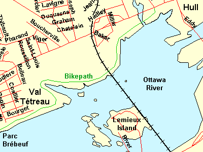 Map of Hull to Val Tétreau Bikepath
Site Description and Birding Information: This bicycle and walking path closely follows the Ottawa River through lovely deciduous woodland. The terrain is full of ups and downs as it winds its way around Squaw Bay, a small inlet opposite the islands. It continues through to the next site, Parc Brébeuf and beyond. Do as much or as little of it as pleases you. The entire length is worth birding during migration. Good views of the Ring-billed Gull colony on the islands in the river can be had.
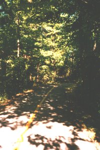 View of bike path
Ottawa River West: Quebec Route Directions: From the bridge at Brewery Creek, drive along Boulevard Alexandre-Taché to the west 1.7 km to Rue Bégin. Turn left or south onto Bégin and go 0.4 km to a small parking area at the end of the street at our next site on this route, Parc Brébeuf.
Return to Ottawa River West: Quebec.
Return to Birding Ottawa Table of Contents.
|