REMIC RAPIDS
Spring: ** Summer: * Fall: ** Winter: *
Independent Directions to this Site: From Highway 417 (The Queensway) take exit 122 (Parkdale Avenue). The eastbound exit ramp comes to a stop sign at Parkdale Avenue in 0.1 km, while the westbound exit ramp becomes Westmount Avenue and reaches Parkdale Avenue in 0.2 km. Turn north onto Parkdale and proceed 1.7 km to the Ottawa River Parkway, passing Wellington and Scott Streets on the way. Pass under the Ottawa River Parkway. Continue 0.3 km round a 270 degree righthand turn to join the Ottawa River Parkway. Continue 0.8 km southwest along the Parkway to the Remic Rapids Lookout turnoff. Turn right or northwest into the parking area at Remic Rapids.
Ottawa River West: Ontario Route Directions: When leaving the Coats Building from Parkdale Avenue and Columbine Street, travel 0.3 km northwest and pass under the Ottawa River Parkway. Continue 0.3 km round a 270 degree righthand turn to rejoin the Ottawa River Parkway. Continue 0.8 km southwest along the Parkway to the Remic Rapids Lookout turnoff. Turn right or northwest into the parking area at Remic Rapids.
Site Description and Birding Information: This spot, part of the National Capital Commission parkland extending along the river to Britannia, features an excellent view of the Little Chaudière Rapids to the northeast and the Remic Rapids to west and northwest. A spotting scope can be very useful here. It also has a small beach which is sometimes open for swimming, if the fecal coliform count is low enough. Be sure to check out the "stone-stacker's" work, along the river, just to the east of this site.
This is one of the regular river-watching stops. Especially good for wintering waterfowl and early winter gulls. A good lookout for birds migrating along the river, including shorebirds in late summer and fall, and gulls and terns in spring and early summer.
Less common species seen from here with some frequency are Horned Grebe, Red-necked Grebe and Barrows Goldeneye. Look for one or two of the latter, from late October to late April, with the flock of Common Goldeneye feeding or resting on the open water created by the rapids. Uncommon birds observed here occasionally include Arctic Tern (late May - early June), Brant (on migration - sometimes a bird or two lingers), Red-throated Loon, Bald Eagle, Bonapartes Gull, Lesser Black-backed Gull, Glaucous Gull and Iceland Gull. Rarities seen from here include: Cattle Egret (June 6, 1986), Harlequin Duck (Nov. 28,1987), Thayers Gull (Oct. 31, 1987 & Apr. 2, 1994), Laughing Gull & Little Gull (Jun. 17, 1989), Franklins Gull (Jun. 17, 1989 & Sep. 30, 2005), Caspian Tern (May 13, 1990 & Apr. 24, 1992), a lingering Whimbrel (Aug. 30 to at least Sept. 21, 2004), Harlequin Duck (Nov. 14, 2005).
Dont forget to check the bushes and trees during migration, and during winter (Bohemian Waxwing has been had here).
Ottawa River West: Ontario Route Directions: When leaving Remic Rapids parking area, turn right or southwest and proceed 1.1 km to another pulloff on the right. Turn right or west into the parking lot for another view of the Remic Rapids at the base of the Champlain Bridge. This view is normally not as productive, but when searching for a species known to be hanging around the rapids, it provides another opportunity to find it. It is also a handy parking spot from which to check Bate Island when the access roads from the bridge are closed. Sometimes the road is cordoned off to Bate Island, so it is necessary to park here or near the far side of the bridge (where traffic is a major problem). Proceeding on foot from the parking lot, the birder can go directly to the nearest access to the south end of the bridge and follow the sidewalk northwest 0.5 km to the Bate Island turnoff. If the roads are open, the instructions that follow will work. Leave the parking area and turn right again on the Ottawa River Parkway and proceed 0.2 km (or 1.3 km from Remic Rapids) southwest to the junction with Island Park Drive and the Champlain Bridge. Turn right or north onto the Champlain Bridge and go northwest 0.7 km (part way) across it, making a right-hand turn into the next site Bate Island.
Return to Ottawa River West: Ontario.
Return to Birding Ottawa Table of Contents.
|
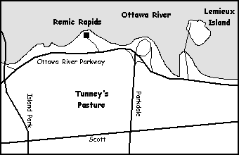 Map of Remic Rapids
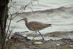 Whimbrel at Remic Rapids - Sept. 17, 2004
|