LEMIEUX ISLAND
Spring: ** Summer: * Fall: * Winter: **
Independent Directions to this Site: From Highway 417 (The Queensway) take exit 122 (Parkdale Avenue). The eastbound exit ramp comes to a stop sign at Parkdale Avenue in 0.1 km, while the westbound exit ramp becomes Westmount Avenue and reaches Parkdale Avenue in 0.2 km. Turn north onto Parkdale and proceed 1.2 km to Burnside Avenue, passing Wellington and Scott Streets on the way. Turn right or east onto Burnside and proceed 0.4 km to where it splits into Slidell Street and Bayview Road. Turn left or north onto Slidell and follow it for 0.1 km where it crosses the Ottawa River Parkway and becomes River Street. Cross the Parkway to River Street and park off the roadway short of the gate and proceed on foot north to Lemieux Island.
Ottawa River West: Ontario Route Directions: From Crowne Plaza Hotel head southwest on Laurier Avenue. Travel 0.1 km southwest along Laurier to Bay Street. Turn right or northwest onto Bay and in 0.3 km you will come to Wellington Street. Turn to the left or southwest onto Wellington Street and go 0.3 km to where the Ottawa River Parkway begins. Bear left onto the Parkway, following it westward for a further 1.5 km to River Street. You will pass the Lebreton Flats, an area subject to development in the near future. Turn right or northwest onto River Street. Park off the roadway short of the gate and proceed on foot north to Lemieux Island.
Site Description and Birding Information: This roughly 200 by 400 metre island is in the centre of the Ottawa River, which is around 800 metres wide here. It has a railroad bridge crossing the river on its east and is the site of a water filtration plant accessed via River Street. Just to the west of Lemieux Island are several small islands (owned by NCC) and the Little Chaudière Rapids. The most northerly islands are on the Quebec side of the provincial boundary, which almost touches the two points on the north side of Lemieux Island. Lazy Bay, south of these smaller islands, is formed by the causeway to Lemieux Island.
Ring-billed Gull and Double-crested Cormorant breed on the islands. Because of its position below the Little Chaudière Rapids, this is a good place to observe wintering waterfowl. Barrows Goldeneye can be seen here sometimes. Rare ducks spotted here over the years include King Eider (Dec. 18, 1983) and Harlequin Duck (Nov. 28, 1987).
Ottawa River West: Ontario Route Directions: When leaving return southeast on River Street to the Ottawa River Parkway. Turn right or west onto it. A slight aside here will provide a possibility of viewing a Peregrine Falcon. A spotting scope is necessary for this site. Drive west and southwest 0.5 km on the Ottawa River Parkway to the Parkdale Avenue exit. Take that exit to the right and loop around to the left 0.5 km, passing under the Ottawa River Parkway. The road continues southeast as Parkdale Avenue. Look for the tallest building, ahead and to the right. This is the next site, the Coats Building, a part of Statistics Canadas Tunneys Pasture complex.
Return to Ottawa River West: Ontario.
Return to Birding Ottawa Table of Contents.
|
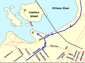 Map of Lemieux Island
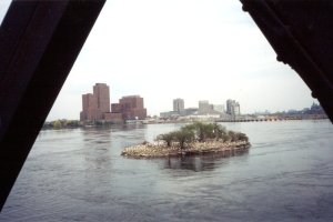 Ring-billed Gull Nesting Island from Lemieux Island Railway Bridge
|