GRANDE & PETITE PRESQU'ÎLE
Spring: **** Summer: ** Fall: *** Winter: *
Independent Directions to this Site: Going north on Autoroute de la Gatineau or Highway 5 take Exit # 2, the Autoroute 50 east exit. Follow the long, 1.0 km, ramp over Brewery Creek and onto Autoroute 50 headed north. Proceed 30 km to exit 166 (the final exit on 50 at this time), following the exit ramp 0.6 km as it loops back around to Rue Notre-Dame. Turn left or south and go 0.6 km SSE to where Chemin de Montréal or Highway 148 join Notre-Dame. Continue straight SSE 0.2 km to where Chemin de la Quai splits off to the right. Continue on Chemin de Montréal or Highway 148 by bearing left or ENE and going 25.6 km on it to the town of Plaisance and Chemin des Presqu'îles. Turn right or south onto it and drive 0.6 km the gatehouse for Grande & Petite Presqu'île in parc national de Plaisance or the Plaisance Provincial Park.
Ottawa River East: Quebec Route Directions: When you have reached the end of the road through the Plaisance Sector - parc national de Plaisance and encountered Chemin des Presqu'îles, turn left or south onto it and go 0.4 km the the gatehouse for Grande & Petite Presqu'île in parc national de Plaisance.
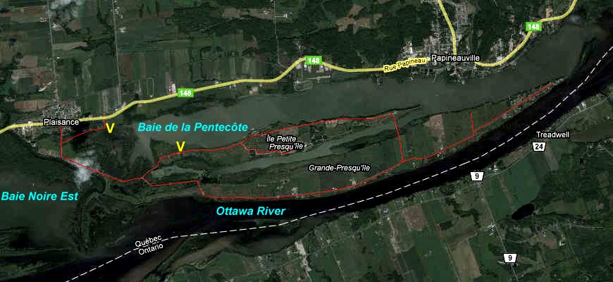 Google Satellite Map of Grande & Petite Presqu'île Area
Site Description and Birding Information: This area is just beyond the OFNC checklist circle, but is an important Outaouais location. It is the "centre" of the newly created Plaisance Provincial Park or parc national de Plaisance. The area is presently being developed as a new park that extends 22.5 km from Thurso, through the Presqu'îles, to as far east as Île à Roussin. This sector consists of the finger-like peninsulae of the Presqu'îles, La Grande Presqu'île to the south and La Petite Presqu'île to the north. Camping facilities are found on La Petite Presqu'île.
For years now this has been the site of a Wild Goose Festival each spring. And for good reason. This is one of the premier sites in this part of the world for observation of migrating waterfowl. Because it is now a official park, there is a fee to enter this area ($5.50 per adult in 2011). Family rates, group rates and annual passes are available for the park and for the park system. In early spring, the gatehouse may only be manned on weekends.
Only 1.3 km after passing the toll house, the road splits. The southeastern fork, Chemin de la Grande Presqu'île, parallels the Ottawa River for 5.2 km before heading north 0.8 km to meet the northeastern fork which has parallelled the Baie de la Pentecôte for around 5.2 km. The roads form a loop around both the Presqu'îles and the bicycle path roughly parallels it, but covers different areas in many cases.
Tens of thousands of Canada Geese stage in this area, especially in the Baie de la Pentecôte. About a kilometre from the fork, at the top of a hill overlooking the bay, there is a huge wooden blind. This is known locally as Le Promontoire. Parking is on the opposite side of the road. Gray Partridge, uncommon in the Outaouais, can be found here.
Rare species seen at this site include: Pink-footed Goose (April 17 - 28, 2004), Great Gray Owl (Feb. 1, 2005 & Apr. 9, 2005), Trumpeter Swan (2- April 12, 2006), American White Pelican (Jul. 22, 2007; Aug. 22, 2008), Cattle Egret (Oct. 30 2010), Greater White-fronted Goose (Apr. 9, 2011).
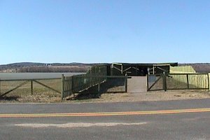 Blind at Le Promontoire overlooking the Baie de la Pentecôte
Ottawa River East: Quebec Route Directions:This is the final site in this linear route. If you have time, you may wish to visit some of the other Northwest quadrant sites. You may also cross the river and try some Southeast sites in Ontario. However, you must now return to the Masson ferry to find your way across the river, since the Thurso ferry has ceased operation. Direct return to the city would be best via Highway 148 and Autoroute 50.
Return to Ottawa River East: Quebec.
Return to Birding Ottawa Table of Contents.
|