BAIE NOIRE
Spring: *** Summer: *** Fall: *** Winter: **
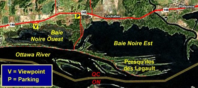
Independent Directions to this Site: Going north on Autoroute de la Gatineau or Highway 5 take Exit # 2, the Autoroute 50 east exit. Follow the long, 1.0 km, ramp over Brewery Creek and onto Autoroute 50 headed north. Proceed 30 km to exit 166 (the final exit on 50 at this time), following the exit ramp 0.6 km as it loops back around to Rue Notre-Dame. Turn left or south and go 0.6 km SSE to where Chemin de Montréal or Highway 148 join Notre-Dame. Continue straight SSE 0.2 km to where Chemin de la Quai splits off to the right. Continue on Chemin de Montréal or Highway 148 by bearing left or ENE and going 21.3 km. Turn right or south into the old gravel road, now gated, that used to allow access to fishermen, picnicers, canoeists and birders between the eastern and western parts of Baie Noire. Near the corner with 148, there is a parking area on the right or west side of the road for Baie Noire. It is 1.7 km to the bridge between Baie Noire East and West; and 1.8 km to the east-west trail (bike path) allowing access to both halves of the bay.
Ottawa River East: Quebec Route Directions: From the Baie Noire West Overlook, continue east 1.9 km on Chemin de Montréal Ouest or Highway 148. Turn right or south into the old gravel road, now gated, that used to allow access to fishermen, picnicers, canoeists and birders between the eastern and western parts of Baie Noire. Near the corner with 148, there is a parking area on the right or west side of the road for Baie Noire. It is 1.7 km to the bridge between Baie Noire East and West; and 1.8 km to the east-west trail (bike path) allowing access to both halves of the bay.
 MS Virtual Earth Satellite Map of the Baie Noire Area
Site Description and Birding Information: This area is part of the newly created parc national de Plaisance or Plaisance Provincial Park. The area is presently being developed as a new park that extends 22.5 km from Thurso, through the Presqu'îles, to as far east as Île à Roussin. This parking area provides a convenient access point to explore Baie Noire. Formerly this road allowed vehicular access along the higher ground between Baie Noire East and West and to Presqu'îles des Legault, the finger-like series of points forming the southern bound of Baie Noire East. The causeway along this road was a very popular fishing, picnicing and boat launching site for the local folks and park officials are considering reopening the road into this point. But, at present, it is gated near Highway 148 and only foot and bicycle traffic allowed. The bike path extends to Thurso and passes between Baie Noire West and the Ottawa River. The old roadway extends out onto Presqu'îles des Legault. Two Great Gray Owls were seen here Feb. 19, 2005 during the invasion that winter.
Baie Noire West is the site of a large Black Tern breeding colony. Other breeding birds include Wood Duck, Marsh Wren, Pied-billed Grebe, Common Moorhen, American Coot, Virginia Rail. Deciduous woods along the old roadway provide good opportunities for land bird migrant viewing. On Nov. 12, 2007 3 Greater White-fronted Geese were seen from here in Baie Noire West. A male Eurasian Wigeon was here from c. Oct. 17 to at least Oct. 24, 2008.
Baie Noire East provides more open water, with potential for migrant waterfowl. In mid-August 2006 numbers of Great Egrets visited here. Up to 12 gathered here on Aug. 13 to 15, 2006; with at least 6 still present on Aug. 17, 2006.
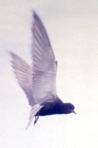 Black Tern at Baie Noire Nesting Colony - July 1, 1990
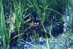 Black Tern Nest at Baie Noire Nesting Colony - July 1, 1990
Ottawa River East: Quebec Route Directions: From the Baie Noire parking area, return to Chemin de Montréal Ouest or Highway 148 and continue east 5.5 km on it to about 1 km past the town of Plaisance. Turn right or south into the entrance to the next site on this route, the Plaisance Sector of parc national de Plaisance.
Return to Ottawa River East: Quebec.
Return to Birding Ottawa Table of Contents.
|