THURSO MARSH (MARAIS PERRAS)
Spring: ** Summer: *** Fall: ** Winter: *
Independent Directions to this Site: Going north on Autoroute de la Gatineau or Highway 5 take Exit # 2, the Autoroute 50 east exit. Follow the long, 1.0 km, ramp over Brewery Creek and onto Autoroute 50 headed north. Proceed 30 km to exit 166 (the final exit on 50 at this time), following the exit ramp 0.6 km as it loops back around to Rue Notre-Dame. Turn left or south and go 0.6 km SSE to where Chemin de Montréal or Highway 148 join Notre-Dame. Continue straight SSE 0.2 km to where Chemin de la Quai splits off to the right. Continue on Chemin de Montréal or Highway 148 by bearing left or ENE and going 15.2 km to Rue Galipeau. Turn right or south on it and drive 0.9 km to the old ferry dock. Pull off to the left or east just before reaching the dock and park at the entrance to the Thruso Marsh.
Ottawa River East: Quebec Route Directions: From the Thruso Settling Pond dirt road, proceed 1.4 km ENE on Chemin de Montréal Ouest or Highway 148 to Rue Galipeau. Turn right or south on it and drive 0.9 km to the old ferry dock. Pull off to the left or east just before reaching the dock and park at the entrance to the Thruso Marsh.
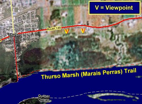 Google Sattelite Map of the Thruso Marsh Area
Site Description and Birding Information: This important site is now part of the newly created parc national de Plaisance or Plaisance Provincial Park. In French, it is called parc national de Plaisance. This new park extends 22.5 km from Thurso, through the Presqu'îles, to as far east as Île à Roussin. The area is being slowly developed as a park. One of the main features will be a bicycle path from the present site through to the Presqu'îles. The plan presently calls for a visitor's centre to be built at the Thurso end, near where we are now parked.
At present the old trail to the marsh is still walkable, but soon to be replaced by a pay-per-view bike path. It is about a kilometre to the marsh through deciduous woodland along the Ottawa River (watch for migrant landbirds in migration). There is a small mound along the trail at the marsh which provides a bit of elevation for viewing. A side trail from it leads to a tower. The old viewing platform, that had fallen into ruin, has been replaced by a new tower. The Thurso Marsh itself (a.k.a. Marais Perras, Marais de Thruso or Baie Perras) is designated a protected area within the park and aside from the trails, should be left untrodden.
Breeding birds include Marsh Wren, Pied-billed Grebe, Common Moorhen, American Coot, Virginia Rail and the rarer Least Bittern. Other birds seen in summer include Black Tern and Black-crowned Night Heron. King Rail has been reported from this site. A Great Gray Owl invader stopped here Jan. 31, 2005.
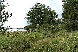
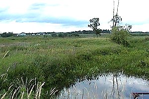 Views of the Thruso Marsh Area
Ottawa River East: Quebec Route Directions: From the Thruso Marsh parking area, return to Rue Galipeau and go north 0.9 km to Chemin de Montréal Ouest or Highway 148. Turn right or ENE on it and drive 1.3 km. An excellent overview of the Thurso Marsh (a.k.a. Marais Perras, Marais de Thruso or Baie Perras) can be had from the next site on this route, the Thruso Marsh Overlook.
Return to Ottawa River East: Quebec.
Return to Birding Ottawa Table of Contents.
|