THURSO SETTLING POND
Spring: ** Summer: ** Fall: ** Winter: *
Independent Directions to this Site: Going north on Autoroute de la Gatineau or Highway 5 take Exit # 2, the Autoroute 50 east exit. Follow the long, 1.0 km, ramp over Brewery Creek and onto Autoroute 50 headed north. Proceed 30 km to exit 166 (the final exit on 50 at this time), following the exit ramp 0.6 km as it loops back around to Rue Notre-Dame. Turn left or south and go 0.6 km SSE to where Chemin de Montréal or Highway 148 join Notre-Dame. Continue straight SSE 0.2 km to where Chemin de la Quai splits off to the right. Continue on Chemin de Montréal or Highway 148 by bearing left or ENE and going 13.8 km. Pull off to the right or south opposite the Nexfor water tower entrance at the dirt road into the Thruso Settling Pond.
Ottawa River East: Quebec Route Directions: From the Marais aux Massettes overlook, proceed 2.4 km northeast on Chemin de Montréal Ouest or Highway 148. Pull off to the right or south opposite the Nexfor water tower entrance at the dirt road into the Thruso Settling Pond.
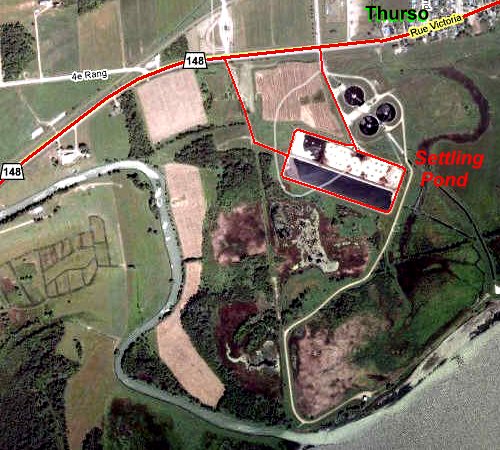 Google Satellite Map of the Thruso Settling Pond Area
Site Description and Birding Information: This site is included because of its shorebirding potential. It is on the grounds of the Nexfor plant and hence is on private property. Please respect it as such. In the past birders have been either tolerated, ignored or not noticed. The main road into the pond (a bit beyond the dirt road described here) has a security gate, but the dirt road has only an oldish gate that is often open and no signage to indicate restricted access. This road leads to the pond and continues around the berm providing excellent viewing. The smell is indescribable. The "water" level varies but there is often exposed sludge. A good variety of shorebirds have been seen here over the years. To the south of the pond, on the other side of the brem, is a cattail marsh.
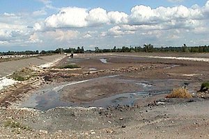
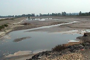 Views of the Thurso Settling Pond on Different Days
Ottawa River East: Quebec Route Directions: From the Thurso Settling Pond dirt road, proceed 1.4 km ENE on Chemin de Montréal Ouest or Highway 148 to Rue Galipeau. Turn right or south on it and drive 0.9 km to the old ferry dock. Pull off to the left or east just before reaching the dock and park at the entrance to the next site on this route, the Thurso Marsh.
Return to Ottawa River East: Quebec.
Return to Birding Ottawa Table of Contents.
|