MONT SIR-WILFRID
Spring: *** Summer: *** Fall: * Winter: *
Independent Directions to this Site: Mont Sir-Wilfred is over 3 hours north of Ottawa by car. Although only 140 km away by air, it is nearly 200 by roads, most of which are narrow and winding. From Ottawa take the MacDonald-Cartier Bridge to Hull and Highway 5. Follow Highway 5 for 1.3 km to exit 2. Bear right onto Autoroute 50/Highway 148 for 2.3 km, then exit right onto Highway 307. Looping under Autoroute 50 and heading northwest, follow 307 north for 21.7 km to where Highway 366 joins it. Follow the combined 307/366 for an additional 7.3 km, until 366 leaves to the right. Continue straight on 307 for another 37.6 km to Highway 309. Turn left or north on 309 and follow it 90.5 km to Mont-Laurier and Highway 117. Turn right or east on 117/309 and proceed 1.5 km to the 309 turnoff. Turn left or north again on 309 and drive 17.8 km to Montée Leblanc on the left just prior to reaching Ferme-Neuve. Turn left on Montée Leblanc and go 1.8 km to Chemin 17. Turn left or west onto it and proceed 13.3 km to Chemin du Windigo. Turn left or west onto Chemin du Windigo and at 6 km bear left or south at the junction and drive a further 11 km to the peak of Mont Sir-Wilfred. From Ferme-Neuve the signs for "Chute du Windigo" and "Montagne du Diable" are handy route markers to follow. Be aware these latter roads are unpaved.
Alternately, as advised by Le club des ornithologues de l'Outaouais (COO), you could follow Highway 309 an additional 1.5 km (19.3 from Mont-Laurier) through Ferme-Neuve to 16e rue. Turn left or west on 16e rue, cross the bridge and drive 2.0 km to a fork. Take the left or SW trending fork and go 1.5 km to Chemin 17. Turn right or NW on it and join those having come up via Montée Leblanc. Proceed 12.5 km to Chemin du Windigo. Turn left or west onto Chemin du Windigo and at 6 km bear left or south at the junction and drive a further 11 km to the peak of Mont Sir-Wilfred. From Ferme-Neuve the signs for "Chute du Windigo" and "Montagne du Diable" are handy route markers to follow. Be aware these latter roads are unpaved.
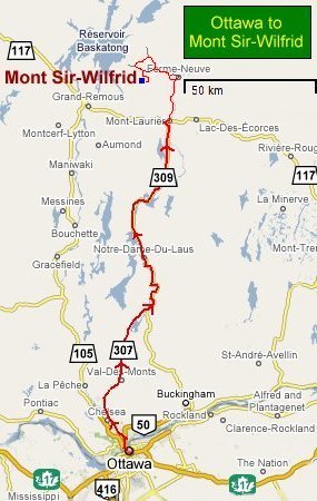 Ottawa to Mont Sir-Wilfred Route Map (GoogleMaps)
|
|
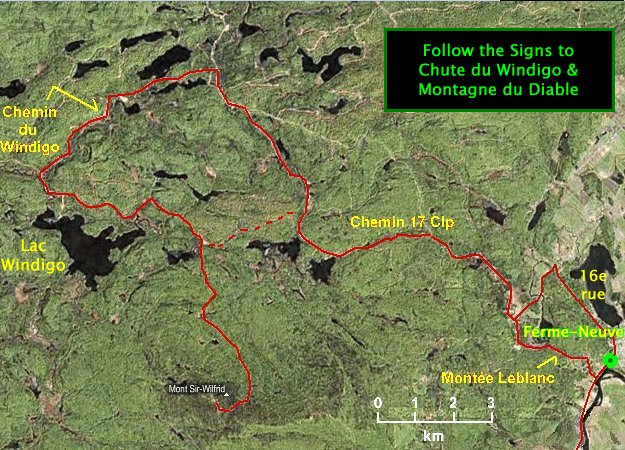 MS Virtual Earth Satellite Image Map of the Mont Sir-Wilfred Area
|
Site Description and Birding Information: Mont Sir-Wilfrid, 783 metres (2569 feet) high, aside from having an amazing view (on a fine day), hosts the most north-westerly population of Bicknell's Thrush. Though it has not been accepted on the Ottawa checklist since its split from the Gray-cheeked Thrush, this outlying breeding colony is a mere 140 km due north of Ottawa. As the birds migrate south; it is fair to assume they pass through the Ottawa checklist circle.
It is likely present on Mt. Sir-Wilfrid from late May or early June to early September, but most easily found when singing in June from the conifers along the roadway. Their calls on territory are quite distinct from that of the Gray-cheeked Thrush, which is similiarly plumaged. For a discussion of Gray-cheeked Thrush identification, click here.
Return to Favourite Outlying Sites.
Return to Birding Ottawa Table of Contents.
|