WHITNEY ROAD MARSH
Spring: ** Summer: ** Fall: ** Winter: *
Independent Directions to this Site: From the junction of Highways 417 (The Queensway) and 416, go south SSE on 416 for 41 km to exit 34, or County Road 43, the Kemptville turnoff. Exit right off 416 and turn left, or ESE, onto CR43. Proceed east 3.0 km to county Road 22, then turn right or SSE onto it. Drive 4.0 km to Whitney Road. Turn right or WSW onto Whitney and go 0.9 km to view the Whitney Road Marsh.
South Gower / Mountain Loop Directions: From the Bennett Road Quarry return WSW to Couny Road 22 and turn left or SSE onto it. Drive 0.3 km to Whitney Road, on the right. Turn right or WSW onto Whitney and proceed 0.9 km to the last site on this route, the Whitney Road Marsh.
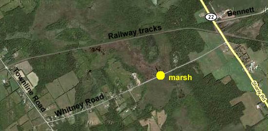 Google Satellite Map of the Whitney Road Marsh
Site Description and Birding Information: This extensive marsh crosses the road at this point providing good opportunities for birding. It also extends all the way to the railway tracks 0.6 km to the north, where it is even wider.
South Gower / Mountain Loop Directions: This is the final stop on the South Gower / Mountain Loop. To return to Ottawa, continue to the west end of Whitney Road, 1.8 km WSW of the marsh, and turn right or NNW onto Townline Road. Follow Townline 4.1 km to County Road 43, noting the sharp right just before CR43. At CR43 turn left or west and go 0.5 km to Highway 416. Turn right or north onto 416 and return the 41 km to Highway 417 in Ottawa.
Return to South Gower / Mountain Loop.
Return to Birding Ottawa Table of Contents.
|