MILL OF KINTAIL CONSERVATION AREA
Spring: *** Summer: ** Fall: ** Winter: **
Independent Directions to this Site: From Highway 417 (The Queensway) take exit 155 (March Road or Regional Road 49). Turn left or southwest onto March Road and follow it for 15.5 km through Almonte to Lanark 29. Turn right or northwest on it and drive 3.0 km to Clayton Road. Turn left or southwest onto it and go 1.5 km to Ramsey Concession 8. Turn right or northwest onto it and proceed 1.9 km to the turnoff, on the right or northeast, to the Mill of Kintail Conservation Area.
Mississippi River Valley Route Directions: From the Almonte Sewage Lagoons viewing tower trailhead, where you are parked, continue northwest for 4.7 km on Ramsey Concession 8 to the turnoff, on the right or northeast, to the Mill of Kintail Conservation Area.
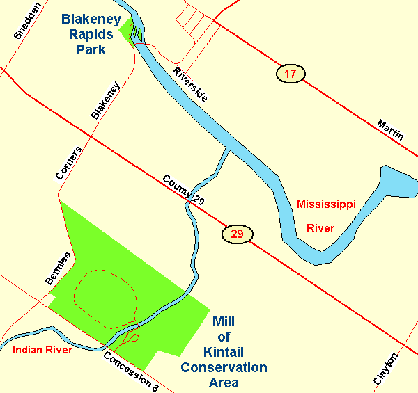 Map of the Mill of Kintail Conservation Area
Site Description and Birding Information: This rectangular (1.5 by 0.8 km) conservation area is located on the beautiful Indian River, only 1 to 2 km before it reaches the mighty Mississippi. It is a popular picnic area in summer and can be crowded on special occasions. The old grist mill, for which the site is named, was built in 1830; and restored in 1930 by Robert Tait McKenzie. A day fee of $5 is requested on entry.
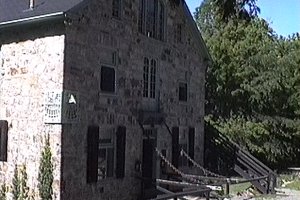 The Mill of Kintail
|
 The Beautiful Indian River
|
Follow the road to the left down to the old mill. Just beyond this there is a bridge across the river. This is the beginning of a lovely 3 km trail through a succession of habitats, from mature deciduous forest to fields. This area hosted a Cerulean Warbler on May 16, 1994.
Mississippi River Valley Route Directions: From the Mill of Kintail Conservation Area, turn right or northwest on Ramsey Concession 8 and proceed 0.8 km to Bennies Corners and turn right or northeast on Bennies Corners Road. Follow this road, which becomes Blakeney Road beyond Lanark 29, for 2.3 km to the turnoff, on the left or northwest just before reaching the bridge over the Mississippi River, to the next site on this route, the Blakeney Rapids Park.
Return to Mississippi River Valley.
Return to Birding Ottawa Table of Contents.
|