TRAIL SE OF JOHN KENNEDY ROAD
Spring: ** Summer: ** Fall: ** Winter: *
Independent Directions to this Site: From Highway 417 (The Queensway) take exit 145 (Highway 7). The offramp continues directly as Highway 7. Continue south, the southwest on Highway 7 for 10.5 km to the Upper Dwyer Hill Road. Turn right or northwest onto it and go 4.0 km to Hamilton Side Road. Turn left or southwest onto it and drive 1.5 km to John Kennedy Road. Turn left or southeast onto it and go 0.1 km to the end of the road. Park here to visit the Trail SE of John Kennedy Road.
Mississippi River Valley Route Directions: From the Jinkinson Road Trailway, return south along Jinkinson Road for 1.4 km to Fernbank Road. Turn right or southwest onto it and drive 3.8 km to the Dywer Hill Road. Turn right or northwest onto it and proceed 6.9 km to Hamilton Side Road. Turn left or southwest onto it and go 1.5 km to John Kennedy Road. Turn left or southeast onto it and go 0.1 km to the end of the road. Park here to visit the Trail SE of John Kennedy Road.
 Map of the Trail SE of John Kennedy Road area
Site Description and Birding Information: Between Hamilton Side Road and McCarton Road it is 3 kilometres. Lowe Road extends 1 km northwest from McCarton and John Kennedy Road 0.1 km southeastward from Hamilton. Between them the old roadway extends nearly 2 kilometres through a good variety of habitat. Park off to the side near the end of the driveable portion of John Kennedy and begin to hike. Rubber boots are recommended. A beaver dam has to be crossed not far in and may be hazardous.
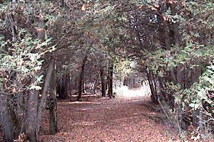 Trail SE of John Kennedy Road Goes through a Cedar Bower
|
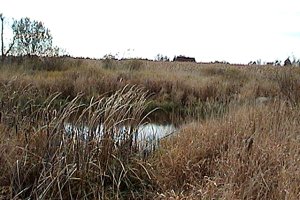 Pond along Trail SE of John Kennedy Road
|
The old road goes through second growth, patches of cedar, fields and swamp. Where a trail branches to the left or northeast, there is a managed pine forest, with both red and white pine plantations. A pond and corn fields complete the picture, attacting deer and Wild Turkey.
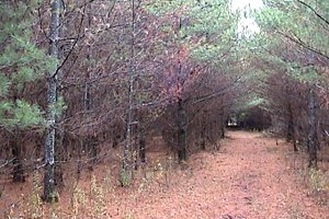 Pine Plantation off Trail SE of John Kennedy Road
On the way to this site, along the Upper Dwyer Hill Road, between Highway 7 and Hamilton Side Road, watch for Upland Sanpiper.
Mississippi River Valley Route Directions: From the Trail SE of John Kennedy Road, return northwest along John Kennedy Road for 0.1 km to Hamilton Side Road. Turn left or southwest onto it and drive 1.4 km to Golden Line Road. Turn left or southeast onto it and proceed 5.1 km, on what is now Ashton Station Road, to next site on this route, the Ashton Station Trailway, just short of Highway 7.
Return to Mississippi River Valley.
Return to Birding Ottawa Table of Contents.
|