LAKE MADAWASKA
Spring: ** Summer: ** Fall: ** Winter: **
Independent Directions to this Site: From Highway 417 (The Queensway), take the Antrim exit and drive northeast 0.8 km to Antrim and Highway 17. Turn left or northwest on 17 and go 6.2 km to the Galetta Sideroad. Turn left onto it and drive 3.0 km to where it becomes Highway 15 (Lanark 29). Then continue southwest for another 1.1 km to leave Highway 15, but continue straight southwest onto Shaw Road or Lanark 22. Continue 1.3 km further on it to North Pakenham Concession 12. Turn right or northwest onto it and go 1.8 km northwest to Packenham Concession 12. Turn right or northeast onto it and 1.1 km to Head Pond Road. Turn left or northwest on it and proceed 0.7 km to its end at Lake Madawaska.
Mississippi River Valley Route Directions: From Shaw Road & N. Pakenham Conc. 12, go 1.8 km northwest on N. Pakenham Conc. 12 to Ryan Duncan Road. Turn right or northeast onto it and 1.1 km to Head Pond Road. Turn left or northwest on it and proceed 0.7 km to its end at Lake Madawaska.
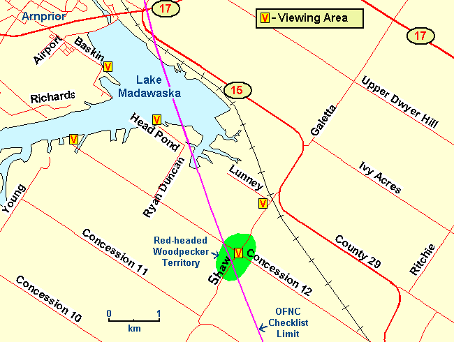 Map of the Lake Madawaska area
Site Description and Birding Information: Only the eastern portion of the headpond is inside the 50 km limit of the OFNC's official study area. Check the lake for waterfowl in season and the fields south of the headpond for Snow Buntings and Lapland Longspurs, as well as raptors, in winter. The end of Head Pond Road has a good view of the water, but is nearly 500 metres west of the circle. Even farther to the west, the end of Packenham Concession 12 has a poorer view, but an interesting gully about a half kilometre from the end. There are three old Loggerhead Shrike records from this general area. One (1975) from the corner of Packenham Concession 12 and Ryan Duncan Road, as well as two mid-80's records nearby - one 2 km west at the northwest end of Packenham Concession 11 (1984 - 85) and one 3.5 km east along the Galetta Side Road (1984). So keep your eyes peeled, you never know.
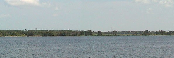 Eastern Shore of Lake Madawaska
An alternate spot to view the headpond from is the southeast end of Baskin Drive (c. 1 km outside the circle). Access from Highway 17, the first left west of the dam, just south of Arnprior.
Mississippi River Valley Route Directions: From the end of Head Pond Road, return 0.7 km to Ryan Duncan Road. Turn right or southwest on it and go 1.1 km to N. Pakenham Concession 12. turn left or southeast on it and proceed 1.8 km to Shaw Road or Lanark 22. Turn left or northeast onto it and drive 1.3 km to Highway 15 (Lanark 29). Turn left onto 15 to continue straight northeast for 1.1 km to the Galetta Side Road or Regional 22. Turn right onto it, continuing straight northeast, and go 4.6 km to MacHardy Road, the next site on this route. Turn left or northwest onto it.
Return to Mississippi River Valley.
Return to Birding Ottawa Table of Contents.
|