MARTEL ROAD EAST END
Spring: ** Summer: *** Fall: ** Winter: ***
Independent Directions to this Site: From Highway 417, 39 km east of Ottawa, take the Limoges exit (79) and go NNW for 4.4 km on Limoges Road (CR 5), through the town of Limoges to the junction of this road with Regional Roads 8 and 37. Follow the right hand curve on Regional 37 or the Saumure/Clarence-Cambridge Boundary Road northeast for 0.9 km to where Saumure turns left. Then continue straight northeast on the Clarence-Cambridge Boundary Road for an additional 9.6 km to Nile Mile Road (Neuf Milles Road). Turn right or SSE onto 9 Mile Road and drive 3.7 km to where Route 200W, Martel and Bertrand Roads come together. Turn left or ENE and go 1.0 km on Martel Road to the deadend at Martel Road East End.
Larose Forest Loop Route Directions: From the junction of Nine Mile, Martel (Route 200W) and Bertrand Roads, go ENE 1.0 km on Martel Road to the deadend at Martel Road East End.
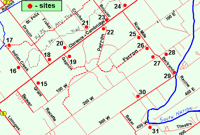 Map of the Martel Road East End Area
Click on other site numbers to go to their pages.
Map of the Martel Road East End Area
Click on other site numbers to go to their pages.
Site Description and Birding Information: East of 9 Mile Road, Route 200 becomes Martel Road, which passes through a good variety of deciduous and coniferous woodland along the way. The entire area can be quite wet in any season but winter, so boots are recommended in warmer months. Insects can be bothersome at that time too.
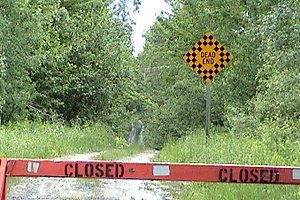 The End of the Line at the East End of Martel Road
Larose Forest Loop Directions: From Martel Road East End return WSW 1.0 km to the junction of Nine Mile, Martel (Route 200W) and Bertrand Roads. Then turn left onto Bertrand Road (the southern extension of Nine Mile Road) and go SSE 1.5 km on Bertrand to the next site on this route, the South Nation River at Bertrand Road and Route 300W.
Return to Larose Forest Loop.
Return to Birding Ottawa Table of Contents.
|