NINE MILE, MARTEL (ROUTE 200W) AND BERTRAND ROADS
Spring: ** Summer: *** Fall: ** Winter: ***
Independent Directions to this Site: From Highway 417, 39 km east of Ottawa, take the Limoges exit (79) and go NNW for 4.4 km on Limoges Road (CR 5), through the town of Limoges to the junction of this road with Regional Roads 8 and 37. Follow the right hand curve on Regional 37 or the Saumure/Clarence-Cambridge Boundary Road northeast for 0.9 km to where Saumure turns left. Then continue straight northeast on the Clarence-Cambridge Boundary Road for an additional 9.6 km to Nile Mile Road (Neuf Milles Road). Turn right or SSE onto 9 Mile Road and drive 3.7 km to where Route 200W, Martel and Bertrand Roads come together. Stop near the junction for Nine Mile, Martel (Route 200W) and Bertrand Roads.
Larose Forest Loop Route Directions: From Perron Road at Nine Mile Road, go SSE on Nine Mile Road for 1.0 km to where Route 200W, Martel and Bertrand Roads come together. Stop near the junction for Nine Mile, Martel (Route 200W) and Bertrand Roads.
 Map of the Nine Mile, Martel (Route 200W) and Bertrand Roads Area
Click on other site numbers to go to their pages.
Map of the Nine Mile, Martel (Route 200W) and Bertrand Roads Area
Click on other site numbers to go to their pages.
Site Description and Birding Information: Exploring the area surrounding this junction of roads and trails can be very productive. There is a good variety of habitat to be found all within a short distance from the crossroads in this south-central area of the forest. Just north of the corner is a goodly stand of pine, while just south is a beautiful creek gully. South of the junction Nine Mile Road becomes Bertrand Road (at least on some maps and signs). Route 200W can be followed 9.8 km to County Road 5 in Limoges. Like all the "roads" in the forest, while it might be driven, especially with a 4-wheel drive vehicle, walking is still the best option. There is a good mix of deciduous and coniferous forest with scattered wooded swamplands along the way. East of 9 Mile Road, Route 200 becomes Martel Road, which is explored in the following site. The entire area can be quite wet in any season but winter, so boots are recommended in warmer months. Insects can be bothersome at that time too.
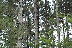 Pines along Nine Mile Road just North of Junction
|
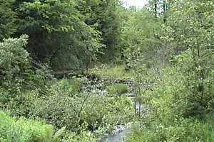 Creek Gully along Bertrand Road just South of Junction
|
Larose Forest Loop Directions: From the junction of Nine Mile, Martel (Route 200W) and Bertrand Roads, go ENE 1.0 km on Martel Road to the next site on this route, Martel Road East End.
Return to Larose Forest Loop.
Return to Birding Ottawa Table of Contents.
|