BOUVIER ROAD FROM ST. FELIX ROAD
Spring: ** Summer: *** Fall: ** Winter: ***
Independent Directions to this Site: From Highway 417, 39 km east of Ottawa, take the Limoges exit (79) and go NNW for 4.4 km on Limoges Road (CR 5), through the town of Limoges to the junction of this road with Regional Roads 8 and 37. Follow the right hand curve on Regional 37 or the Saumure/Clarence-Cambridge Boundary Road northeast for 0.9 km, then turn left or NNW onto Saumure Road (Regional 37) and travel 4.6 km to Russell Road (Regional 26). Turn right or northeast onto Russell Road and proceed 3.6 km to Drouin Road. Turn right or SSE onto Drouin and go 1.5 km to St. Felix Road. Turn left or northeast onto St. Felix and drive 4.7 km to Bouvier Road. Turn right or SSE into Bouvier Road.
Larose Forest Loop Route Directions: From the parking area for the County Road 8 ATV Trail on County Road 8, continue NNW on County Road 8 for 2.0 km to St. Felix Road. Turn left or southwest on St. Felix and drive 2.5 km to Bouvier Road. Turn left or SSE into Bouvier Road.
 Map of the Bouvier Road from St. Felix Road area
Click on other site numbers to go to their pages.
Map of the Bouvier Road from St. Felix Road area
Click on other site numbers to go to their pages.
Site Description and Birding Information: This dirt road, which soon deteriorates into a dirt track, gives access to the northern edge of the Larose Forest. It can be driven, with great caution, during drier times of year, through to the Clarence-Cambridge Boundary Road, 3.5 km to the SSE; but I wouldn't recommend it. It is far better to drive the short distance to forest lands and pull off and park where possible and walk into the woodland. At first, the forest is mostly deciduous with scattered wooded swampland, but as you proceed south there are more conifers. At about 1.5 and/or 1.8 km from St. Felix Road (depending on the branch), you will come to the ATV trail (Rd 25), and at 2.2 km the ski trail. It eventually, in 3.4 km, comes out on the Clarence-Cambridge Boundary Road at the Bouvier Road North of Clarence-Cambridge Boundary Road site. The area can be quite wet in any season but winter, so boots are recommended in warmer months. Insects can be bothersome at that time too.
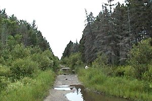 ATV Trail (Road 25) looking Southwest from Bouvier Road
|
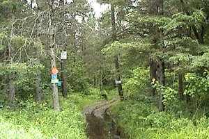 Ski Trail Crossing Bouvier Road
|
Larose Forest Loop Directions: From the junction of Bouvier and St. Felix Roads, turn left or southwest on St. Felix and drive 3.1 km to Fisher Road (Goyer Road on some maps). Turn left or SSE into Fisher to begin the next site on this route, the Fisher Road from St. Felix Road.
Return to Larose Forest Loop.
Return to Birding Ottawa Table of Contents.
|