CHAMPLAIN & GATINEAU PARKWAYS
Spring: ** Summer: ** Fall: * Winter: *
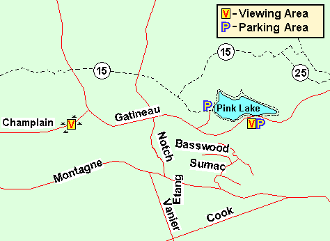
Independent Directions to this Site: From Autoroute de la Gatineau or Highway 5, take exit # 3 or Boulevard St-Raymond heading west. Travel 1.5 km west to Promenade du Lac-des-Fées and turn left or south on it. Follow Lac-des-Fées 0.4 km to Rue Gamelin and turn right or west on it. Go 0.9 km to the (Promenade de la) Gatineau Parkway and turn right or north on it. Proceed 7.5 km northwest, to the junction of the (Promenade de la) Gatineau Parkway with the (Promenade) Champlain Parkway. Turn left or WSW onto the (Promenade) Champlain Parkway and drive 0.1 km to pull off on the ample shoulder and park near the ponds.
Gatineau Park South Route Directions: From the Pink Lake lookoff parking area, return to the (Promenade de la) Gatineau Parkway and turn right or west onto it. Proceed 1.9 km west, to the junction of the (Promenade de la) Gatineau Parkway with the (Promenade) Champlain Parkway. If you have parked in the lot west of the lake, return the 0.3 km SSW to the (Promenade de la) Gatineau Parkway. Proceed 1.2 km west, to the junction of the (Promenade de la) Gatineau Parkway with the (Promenade) Champlain Parkway. In both cases, turn left or WSW onto the (Promenade) Champlain Parkway and drive 0.1 km to pull off on the ample shoulder and park near the ponds.
 Map of the Champlain & Gatineau Parkways area, Gatineau Park
Site Description and Birding Information: This stop has a good combination of habitats, ponds, swamp, and maturing deciduous woodland. Mourning Warbler is a nester here and can sometimes be coaxed into sight in the bushes between the road and the ponds. Olive-sided Flycatcher and Yellow-billed Cuckoo have been reported from this location. The openings provide greater visibility and possible avenues for raptors.
In winter, this section of the parkway is closed to vehicles and is opened to skiing only. Hikers may still use the trails. The exact dates are weather dependent, but usually from mid-November to early April.
 Champlain & Gatineau Parkways Swamp
Gatineau Park South Route Directions: From the swampy area just west of the junction of the Champlain & Gatineau Parkways, continue WSW along the (Promenade) Champlain Parkway for 2.2 km to the pay parking area on the right or north for the Waterfall Trail (fee because of its proximity to the MacKenzie King estate) or a further 0.9 km to the free parking areas for Lac Mulvihill on the right or north and the Larriault Trail on the left or south. All these parking areas are on the trail loop for the next site on this route, the Lauriault Falls and Mulvihill Lake Trail.
Return to Gatineau Park South.
Return to Birding Ottawa Table of Contents.
|