PINK LAKE
Spring: ** Summer: ** Fall: ** Winter: **
Independent Directions to this Site: From Autoroute de la Gatineau or Highway 5, take exit # 3 or Boulevard St-Raymond heading west. Travel 1.5 km west to Promenade du Lac-des-Fées and turn left or south on it. Follow Lac-des-Fées 0.4 km to Rue Gamelin and turn right or west on it. Go 0.9 km to the (Promenade de la) Gatineau Parkway and turn right or north on it. Proceed 5.6 km northwest and turn right into to the parking area for the Pink Lake lookoff. (There is further parking at the west end of the lake. To reach it, continue a further 0.7 km west on the (Promenade de la) Gatineau Parkway and turn right into the parking area, which is 0.3 km NNE along this road.)
Gatineau Park South Route Directions: From the Hickory Trail parking area, return to the (Promenade de la) Gatineau Parkway and turn left or west onto it. Proceed 2.8 km northwest to Pink Lake. Turn right into the parking area and lookoff. (There is further parking at the west end of the lake. To reach it, continue a further 0.7 km west on the (Promenade de la) Gatineau Parkway and turn right into the parking area, which is 0.3 km NNE along this road.)
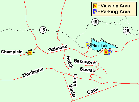 Map of the Pink Lake area, Gatineau Park
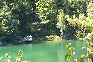
Site Description and Birding Information: A 2.0 km interpretive trail skirts the lake, providing a very scenic walk through lovely cedar and deciduous woodland, some fairly mature. This spot is very popular and may be crowded with people, so go early before the birds have taken cover. The viewpoint overlooking the lake is worth the stop simply because of the gorgeous postcard scene visible from the tower. But parking is better at the west end of the lake. At this second parking area, another trail leads to the main trail (number 15) going through this section of the park, which is also a part of the Trans-Canada Trail.
In winter, this section of the parkway is closed to vehicles and is opened to skiing only. Hikers may still use the trails. The exact dates are weather dependent, but usually from mid-November to early April.
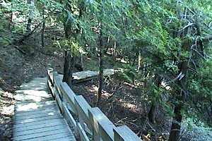
 Pink Lake Interpretive Trail, Gatineau Park
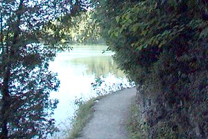
 Viewpoint along Trail around Pink Lake
Gatineau Park South Route Directions: From the Pink Lake lookoff parking area, return to the (Promenade de la) Gatineau Parkway and turn right or west onto it. Proceed 1.9 km west, to the junction of the (Promenade de la) Gatineau Parkway with the (Promenade) Champlain Parkway. If you have parked in the lot west of the lake, return the 0.3 km SSW to the (Promenade de la) Gatineau Parkway. Proceed 1.2 km west, to the junction of the (Promenade de la) Gatineau Parkway with the (Promenade) Champlain Parkway. In both cases, turn left or WSW onto the (Promenade) Champlain Parkway and drive 0.1 km to the next site on this route, the Champlain & Gatineau Parkways. Pull off on the ample shoulder and park near the ponds.
Return to Gatineau Park South.
Return to Birding Ottawa Table of Contents.
|