LUSKVILLE FALLS TRAIL
Spring: ** Summer: ** Fall: ** Winter: *
Independent Directions to this Site: From Boulevard des Allumettières or Highway 148, take the Chemin Eardley exit in Aylmer. Turn right or northwest onto Chemin Eardley or the continuation of Highway 148 and proceed 17.9 km northwest on Eardley to Chemin de l'Hôtel-de-Ville. Turn right or ENE onto de l'Hôtel-de-Ville and drive 0.7 km to the road on the left into Luskville Falls. Turn left or north and proceed 0.3 km to the parking area for the Luskville Falls Trail.
Eardley Escarpment & Gatineau Park Northwest Route Directions: From the western end of Chemin Crégheur at Highway 148, turn right or northwest and drive 2.2 km to Chemin de l'Hôtel-de-Ville. Turn right or ENE onto de l'Hôtel-de-Ville and drive 0.7 km to the road on the left into Luskville Falls. Turn left or north and proceed 0.3 km to the parking area for the next site on this route, the Luskville Falls Trail.
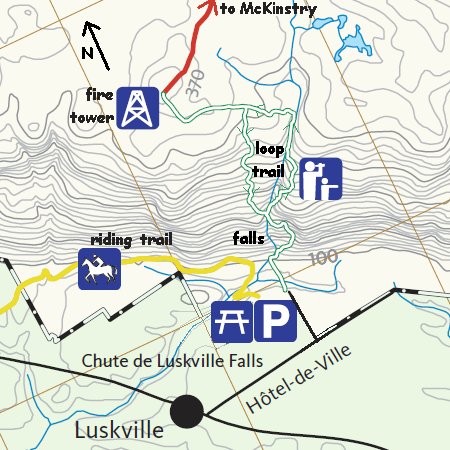 Modified Section of NCC Trail Map Showing the Luskville Falls Trail Area
Site Description and Birding Information: This lovely, but steep, scenic 4.5 km loop trail in Gatineau Park goes north from the parking area at the base of the escarpment to Luskville Falls (dry in summer) in 300 meters, and thence upward (bear right at the fork) to the top of the escarpment and westward to a fire tower in 2.5 km. The fire tower is the terminus of hiking trail 1, coming in from McKinstry to the north. The second portion of the loop breaks off to the right on the return downhill and runs to the west of upward path, joining it where you went right on the way up.
Spring is the best time for the waterfall, while fall is best for the show of colourful leaves. Views are spectacular in all seasons. Birding can be good anytime. Both Bald and Golden Eagles can be seen over the escarpment in this area in winter and increasingly at other times of year. Migrant and breeding land birds no doubt relish the hoards of insects that may drive us batty if we forget our repellent.
At the parking lot there is a picnic area and outhouses. The park asks us to stay on the trail, though at times the official route is not entirely clearcut. The trail has some stairs and some rocky areas. The fire tower at the top is off limits, but the view from near it is stunning.
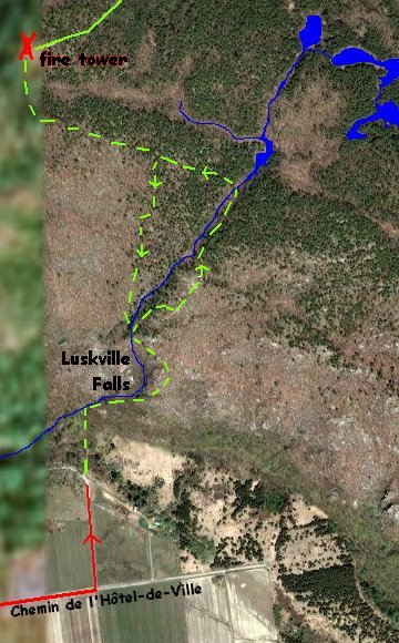 Google Satellite Image Map of the Luskville Falls Trail Area
Eardley Escarpment & Gatineau Park Northwest Route Directions: From Luskville Falls Trail parking area, return south 0.3 km to Chemin de l'Hôtel-de-Ville. Turn right or west an drive 0.7 km to Highway 148 (Chemin Eardley). Turn right or northwest and drive 3.8 km to Chemin Pilon. Turn right or north onto Pilon and drive 1.5 km to the left hand turn of the road at the escarpment. Park near here for the next site on this route, Chemin Pilon (Road).
Return to Eardley Escarpment & Gatineau Park Northwest.
Return to Birding Ottawa Table of Contents.
|