TRILLIUM WOODS & SECOND LINE
(Monk Environmental Park)
Spring: ** Summer: ** Fall: ** Winter: *
Independent Directions to this Site: From Highway 417 (The Queensway) take exit 138 (Eagleson/March Roads). If travelling west, the 0.6 km offramp dumps you right or north onto March Road. If driving east, a 0.5 km offramp brings you to Eagleson Road, where you will turn left or north onto it to March Road (its northward extension) and in 0.5 km join the westbound offramp traffic. Both groups will now follow March Road north, then northwest, 4.0 km to Terry Fox Drive. Turn left or southwest onto Terry Fox and go 0.9 km to Goulbourn Forced Road. Turn left or south on Goulbourn Forced Road and go 1.1 km to the trailhead parking area (basically just a pull off for a couple of cars) on the left.
Dunrobin & Carp Ridges Route Directions: From the Marathon Trail parking lot, turn right or NNW and drive 0.5 km to a small parking area on the right, basically just a pull off for a couple of cars. This is the access point for the Trillium Woods - Second Line area.
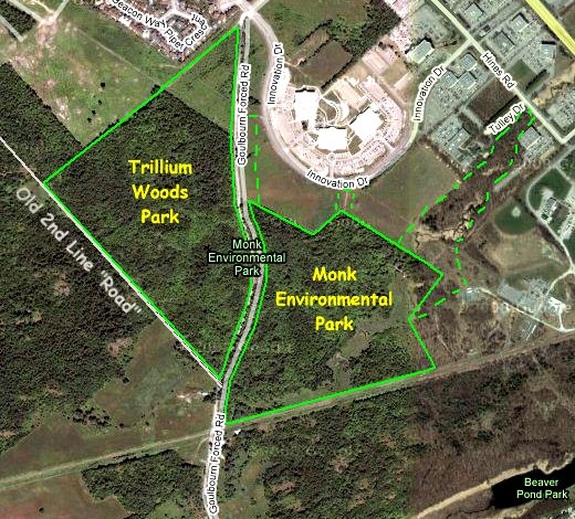 Google Satellite Map of Trillium Woods & Second Line Area
Site Description and Birding Information: You are now in Trillium Woods where a 2.3 km trail froms a loop through which the road passes. The road can be used to make a shorter loop in conjunction with either the east (1.8 km) or west (1.7 km) sections. The prime attraction here is the display of spring wildflowers, starring the trillium. This area has a large stand of mature hardwoods. The southwestern leg of this trail, on the west side of the road opposite your parking spot, is actually the old 2nd Line Road. It extends in a northwesterly direction beyond trail marker 28 all the way to Klondike Road. Here 2nd Line resumes again. This old roadway runs through a good variety of wooded habitats, mostly younger growth. It can be very good during spring migration.
Because this site is on the edge of land currently being "developed", there are many changes recently. The trail on the east side of Trillium Woods became the Mystical Monk Trail, then that side of Trillium Woods became the Monk Environmental Park (as if the disappearing parkland's new name could make up for the rape going on around it), while the west side became Trillium Woods Park. Recent maps suggest both sides are now called Monk Environmental Park. And they also show decreasing boundaries on the northern side of the park (the dotted green lines on the map represent those of former, but recent, years).
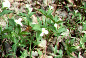 Trillium Woods
Dunrobin & Carp Ridges Route Directions: To reach the next site proceed 2.1 km north on Goulbourn Forced Road through Trillium Woods all the way to Klondike Road. Turn right or northeast and go 0.2 km to March Road (Regional 49). Turn left or northwest onto March Road and travel 3.0 km to a 90 degree lefthand turn and junction. Take a right and continue northwest on Dunrobin Road 1.5 km to Kerwin (River) Road. Turn right or northeast onto Kerwin (River) Road, our next site on this route.
Return to Dunrobin & Carp Ridges.
Return to Birding Ottawa Table of Contents.
|