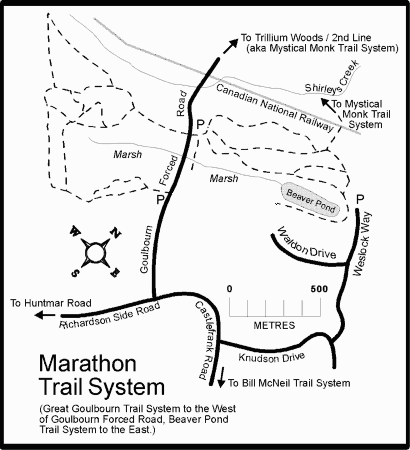
MARATHON TRAIL SYSTEM
Spring: *** Summer: ** Fall: ** Winter: *
Independent Directions to this Site: From Highway 417 (The Queensway) take exit 138 (Eagleson/March Roads). If travelling west, the 0.6 km offramp dumps you right or north onto March Road. If driving east, a 0.5 km offramp brings you to Eagleson Road, where you will turn left or north onto it to March Road (its northward extension) and in 0.5 km join the westbound offramp traffic. Both groups will now follow March Road north, then northwest, 4.0 km to Terry Fox Drive. Turn left or southwest onto Terry Fox and go 0.9 km to Goulbourn Forced Road. Turn left or south on Goulbourn Forced Road and go 1.6 km to the trailhead parking area on the left.
Dunrobin & Carp Ridges Route Directions: From the Bill McNeil Trail at Campeau and Knudson Drives, return 1.4 km west to Castlefrank Road and turn right or north onto it. Wind 1.8 km along Castlefrank Road to Goulbourn Forced Road and Richardson Side Road (which Castlefrank becomes here). Turn right or north and proceed 1.0 km to a parking lot on the right or east side of the road. Park here to hike the Marathon Trail System.
 Map of Marathon Trail System area
Site Description and Birding Information: Trail maps are sometimes available at the parking area. About 0.5 km south along Goulbourn Forced Road there is a large trail map sign where the southern loop crosses the road. Maps are sometimes to be had here too. Between the sign and the parking lot the road crosses a marsh where Virginia Rail, Sora, Green Heron, American and Least Bittern and Marsh Wren have been found.
The eastern section of the trail system, east of Goulburn Forced Road, is not as good as the western portion. The eastern part abuts sub-divisions to the east but does pass a beaver pond and go through a fair variety of woodland habitats including mature hardwood forest, low areas of cedar and mixed hardwood, some eastern hemlock and marshland. Spring migration is the best time to bird here. The main loop here is 2.6 km long, but there are several possible routes because of extra loops here and there along the trail. This adds a pleasant variety. A trail near the northeast corner, at marker # 2, leads north to the Trillium Woods.
The western loop is not only more interesting birdwise, but more beautiful. The outside loop is 2.7 km long, but again, there are several optional cutoffs and alternates. There are overgrown fields adjacent the road, the large marsh mentioned above inside the loop, mature hardwood forest with lots of rock outcrops, a wooded swamp in the southwest corner, and views over farmland occasionally. Best birding during spring migration. Blue-gray Gnatcatcher has been seen on the southern leg in spring. Northern Mockingbird has been seen near the road. Eastern Screech Owls are resident here. Uncommon migrants such as Yellow-throated Vireo and Olive-sided Flycatcher have been seen along this trail system. Wildflowers in spring are breath-taking, especially the trillium and hepatica.
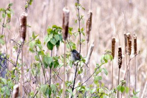 Spamp Sparrow in Central Marsh
Dunrobin & Carp Ridges Route Directions: From the Marathon Trail parking lot, drive 0.5 km to a small parking area on the right, basically just a pull off for a couple of cars. This is the Trillium Woods & Second Line area, our next site on this route.
Return to Dunrobin & Carp Ridges.
Return to Birding Ottawa Table of Contents.
|