TWIN ELM
Spring: *** Summer: * Fall: ** Winter: *
Independent Directions to this Site: From Highway 416 take exit 66 (Fallowfield Road). If southbound, a 0.4 km offramp dumps onto Fallowfield, where you will turn right or west. If northbound, the 0.4 km offramp brings you to Fallowfield, where you will turn left or west onto it and in 0.5 km join the southbound offramp traffic. Both groups will now follow Fallowfield Road west 2.5 km from here, passing Moodie Drive to reach Richmond Road. Turn left or southeast onto Richmond Road and drive 4.5 km to the bridge at Twin Elm.
Stony Swamp Loop Route Directions: From the junction of Rushmore Road and Richmond Road, turn right or SSE onto Richmond and drive the 2.3 km to the bridge at Twin Elm.
Site Description and Birding Information: This site is primarily a spring shorebird spot, with possibilities of waders as well. The grassy riverbanks along the Jock River especially immediately above the bridge are one of the first locations for spring shorebird arrivals in our area. It is worth checking the river for around 3 km south along Richmond Road for shorebirds, waders and waterfowl. Killdeer, Greater and Lesser Yellowlegs are most common, but Pectoral, Least and Solitary Sandpiper have been seen. Once 4 Wilson's Phalarope were spotted here (May 9, 1987).
Such rarities as Ruff (May 2, 1991), Mute Swan (Apr. 18, 1993), and Greater White-fronted Goose (Apr. 8, 2005; Apr. 2, 2006) have turned up here.
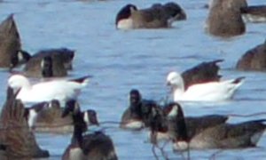 Ross's Geese among Canada Geese at Twin Elm, ON - Mar. 27, 2011
The north end of Twin Elm extending beyond Cambrian Road is subject to flooding some springs and attracts flocks of waterfowl in such springs. On March 20, 2011 a pair of Ross's Geese chose to rest here along with the flock of Canada Geese.
This site is also very close to the Richmond Lagoons location in the Marlborough Forest loop.
Stony Swamp Loop Route Directions: From the bridge at Twin Elm, proceed ENE 0.4 km to the T-junction at Twin Elm Road and turn right or SSE onto it. Follow Twin Elm Road 4.2 km SSE to Regional Road 8 or Brophy Road (this section, from Eagleson Road to Moodie Drive, was formerly also called Bankfield Road). This is the next site on this loop tour, Brophy / Bankfield Road. The low fields lining the 6.7 km of Brophy Road and Bankfield Road (its extension east of Moodie Drive), should be scanned. This area extends from Eagleson Road, 2.2 km to the southwest to Highway 416, 4.5 km to the northeast, of Twin Elm Road.
Return to Stony Swamp Loop.
Return to Birding Ottawa Table of Contents.
|
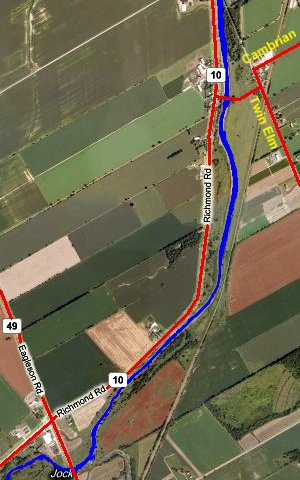 MS Virtual Earth Satellite Map of Twin Elm Area
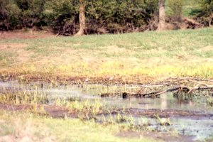 Shorebird Habitat at Twin Elm
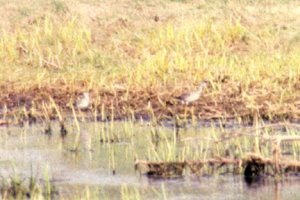 Lesser & Greater Yellowlegs
|
|