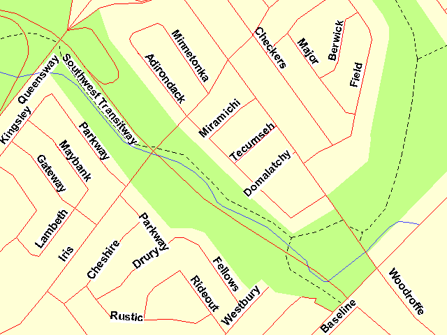
PINECREST CREEK SOUTH
Spring: ** Summer: * Fall: * Winter:*
Independent Directions to this Site: From Highway 417 (The Queensway) take exit 127 (Woodroffe Avenue) south. Go SSE for 0.9 km on Woodroffe to Adirondack Drive. Turn right or WSW into Adirondack and park where able. From here you can access the southern portion of the Pinecrest Creek Pathway.
Ottawa West Park Loop Route Directions: From the Clyde Woods parking area at the north end of the southern portion of Clyde Avenue, return the 0.4 km to Bonnie Crescent. Turn right or southwest onto it and drive 0.1 km to Cameo Drive. Turn left or SSE onto it and go 0.2 km to Maitland Avenue. Turn left or east onto Maitland and follow it as it bends SSE for 0.4 km to Baseline Road. Turn right or southwest onto Baseline and proceed 2.1 km to Woodroffe Avenue. Turn right or NNW onto it and go 0.2 km to Adirondack Drive on the left. Turn left or WSW into Adirondack and park where able. From here you can access the southern portion of the Pinecrest Creek Pathway.
 Map of the Pinecrest Creek South Area
Site Description and Birding Information: This site has as many problems as it has potential. A sliver of "greenspace" about a hundred metres wide, shared by both a busy transitway and a bicycle path, follows the heavily polluted Pinecrest Creek from just east of Baseline and Woodroffe Avenues, NNW for a little over a kilometre to the Queensway (Highway 417). The section north of the 417 is covered on the Pinecrest Creek North site page.
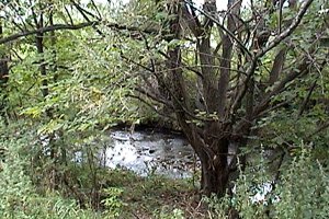
 Pinecrest Creek Gully East of Woodroffe
There is a small area worth checking in migration east of Woodroffe and just north of Baseline Road. A fairly deep, well-treed gully runs behind the businesses on Baseline. Unfortunately, the area is also an unsightly dumping ground for fast food boxes and bags and assorted other garbage. And the creek, if it can be called that rather than a raw sewage outflow, is disgusting. If you can ignore that, you may, as a bird flying over may, see the potential for migrants.
On the west side of Woodroffe, the pathway follows the creek and despite the narrowness of the greenery, provides a variety of habitat and shelter for migrants. The creek, by the nature of the "water" flowing in it, is warm enough to have some open areas in winter. These usually have a few ducks.
 Views of the Pinecrest Creek South Area West of Woodroffe
Ottawa West Park Loop Route Directions: From wherever you are parked along Adirondack Drive, return south and east to Woodroffe Avenue. Turn right or SSE on it and go 1.4 km to Tallwood Drive. Turn right or southwest onto Tallwood and proceed 0.4 km to Centrepointe Drive. Turn right or northwest onto it and drive 0.3 km to turn right and park at the Nepean Civic Square. From here, explore the next site in this loop, the Centrepointe Park.
Return to Ottawa West Park Loop
Return to Birding Ottawa Table of Contents
|