HAMPTON PARK
Spring: ** Summer: ** Fall: ** Winter:*
Independent Directions to this Site: From Highway 417 (The Queensway) take exit 123 (Island Park Drive) if travelling west or exit 124 (Carling Avenue) if driving east. Using the Carling exit requires a bit of manouvring. Immediately upon exiting, in 250 metres, you will merge with Carling Avenue. As left turns are prohibited onto Merivale Road, which joins Island Park Drive, you will want to cross the traffic lanes and turn left onto Kirkwood Avenue and have only another scant 250 metres in which to do it. Be careful! Avoid rush hours, traffic can slow to a crawl. Go NNW on Kirkwood for 0.9 km and turn right on Iona Street. Proceed 0.4 km northeast to Island Park Drive. Turn right or SSE on it and drive 0.3 km to the turnoff, on the right or west to Hampton Park. Here you will join those who travelled west on the 417, who had only to exit onto Island Park Drive and go 0.4 km NNW along it to reach the turnoff, on the left or west into Hampton Park.
Ottawa West Park Loop Route Directions: This is the first site on the loop route. From Highway 417 (The Queensway) take exit 123 (Island Park Drive) if travelling west or exit 124 (Carling Avenue) if driving east. Using the Carling exit requires a bit of manouvring. Immediately upon exiting, in 250 metres, you will merge with Carling Avenue. As left turns are prohibited onto Merivale Road, which joins Island Park Drive, you will want to cross the traffic lanes and turn left onto Kirkwood Avenue and have only another scant 250 metres in which to do it. Be careful! Avoid rush hours, traffic can slow to a crawl. Go NNW on Kirkwood for 0.9 km and turn right on Iona Street. Proceed 0.4 km northeast to Island Park Drive. Turn right or SSE on it and drive 0.3 km to the turnoff, on the right or west to Hampton Park. Here you will join those who travelled west on the 417, who had only to exit onto Island Park Drive and go 0.4 km NNW along it to reach the turnoff, on the left or west into Hampton Park.
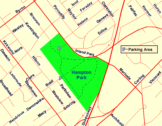 Map of Hampton Park Area
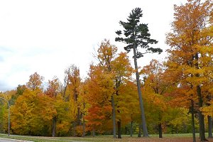
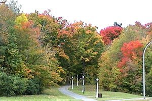
Site Description and Birding Information: This small park (500 by 200 to 300 metres) has some mature woodland with trails, a small stream, and an open area with large trees. Good in migration, birds are happy to see even a small treed area in the midst of wall to wall human shelters. In winter, feeders around the park edges sometimes attract good birds that may be sheltering in the greenery, such as the Tufted Titmouse which stayed from Nov. 15, 1989 to Apr. 14, 1990.
The well-treed neighbourhood to the north of the park, across Island Park Drive, is also attractive to birds. Watch for feeders in this area in winter. Ornimental crab apple trees in the area attract flocks of Bohemian Waxwings in winter, while the fruit lasts. White-winged Crossbill have been seen some winters. Merlins can be heard and seen in summer. A Carloina Wren was seen on Mayfair Avenue on Dec. 18, 1971. This site is also very close to the Central Experimental Farm locations on the Rideau River West Side Route.
Views of Hampton Park
Ottawa West Park Loop Route Directions: From the Hampton Park turn right or SSE onto Island Park Drive and bear right after 0.2 km to turn right onto Merivale Road. Go SSE on Merivale for 2.8 km to Baseline Road. Turn right or southwest on Baseline and proceed 0.8 km to Clyde Avenue. Turn right or NNW onto Clyde and go 0.3 km to where the main road veers left to continue as Maitland Avenue. Continue straight here, turning right off the main road, and proceed another 0.7 km to the end of this section of Clyde Avenue. Pull off to the side and park here for the next site in this loop, Clyde Woods & Quarry.
Return to Ottawa West Park Loop
Return to Birding Ottawa Table of Contents
|