UPPER & LOWER DUCK ISLANDS
Spring: ** Summer: * Fall: ** Winter: *
Independent Directions to this Site: From Highway 417 (The Queensway) take exit 113 (Ottawa-Carleton 174, formerly Highway 17). Stay in the left lanes to take this exit. Go WNW 1.8 km to the Blair Road exit and loop around 270 degrees (0.3 km) to the right to turn right or NNW on Blair. Proceed NNW 3.6 km, passing Montreal Road at 2.0 km. Turn left or west onto an unmarked road just before the overpass and go 0.6 km to the boat launch and parking lot at the Airbase Woods. It is about a half kilometre by boat to the west end of Upper Duck Island.
Ottawa River West: Ontario Route Directions: Upper & Lower Duck Islands are accessible only by boat during the portion of the year when the river is not frozen. If the ice is thick enough to be safe you can walk across in winter, but check first. You don't have to move from the Airbase Woods parking lot, just launch your boat or canoe from the boat launch there. It is about a half kilometre by boat to the west end of Upper Duck Island. Alternately, since the islands extend nearly to the mouth of Green's Creek, you could cross farther downstream.
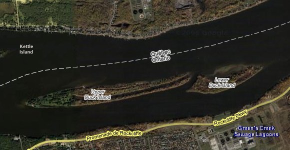 Google Satellite Map of Upper & Lower Duck Islands
Site Description and Birding Information: These two islands, owned by the National Capital Commission, have been preserved in near natural state. This is mainly because they are in the middle of the river and have swampy margins. Upper Duck Island is 2.1 km long and 100 to 200 metres wide, with a central channel running from the east end nearly the length of the island. Lower Duck Island is just over a kilometre long and about 200 metres wide, with a 400 metre hook to the west from the northeastern corner. There are many interesting plant communities on the islands. These islands, being isolated as they are, have not been birded extensively. But during migration should be excellent spots.
Ottawa River West: Ontario Route Directions: From Upper & Lower Duck Islands return to the boat launch and parking lot at the Airbase Woods. Return the 0.6 km to Blair Road and turn right or SSE on it. Go 1.6 km SSE on Blair to Montreal Road. Turn left or ESE on it and drive 2.3 km to Shefford Road. Turn left or NNW onto Shefford and proceed 1.6 km to the end. There is a small parking area here. Go on foot north across the Eastern Parkway to the Ottawa River. The easy walking trail extends from here 2.4 km to the next site on this route, the Mouth of Green's Creek.
Return to Ottawa River East: Ontario.
Return to Birding Ottawa Table of Contents.
|