SOUTHEAST END OF BEAVERTAIL ROAD
Spring: ** Summer: ** Fall: * Winter: *
Independent Directions to this Site: From Highway 417 (The Queensway) take exit 144 north (Carp Road or Regional Road 5). Follow the 0.5 km off-ramp to Carp Road and turn right or northwest onto it, going 1.5 km to Richardson Side Road. Turn left or southwest onto it and follow it for 5.3 km to Beavertail Road. Turn left or southeast on it and drive 1.3 km to the marshes at SE End of Beavertail Road.
Mississippi River Valley Route Directions: From the Trail SE of Howie Road, turn right or northeast onto the Old Almonte Road and go 1.7 km to Beavertail Road. Turn right or southeast onto Beavertail and drive 2.7 km to the marshes at SE End of Beavertail Road.
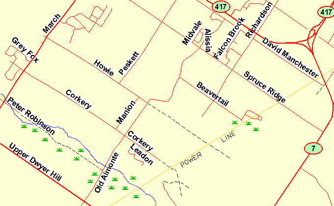 Map of the SE End of Beavertail Road area
Site Description and Birding Information: Just northwest of the southeastern end of Beavertail Road, it crosses a marsh. There is open water, especially on the southwestern side. The water and edges can be viewed here from the roadway. One can also park at the turnout at the corner and walk the the edge of the marsh to the west. Another path, leading southeast off the end of Beavertail Road, goes a short distance to where a more extensive open marsh area can be seen through the screen of bushes. Look and listen for marsh related birds.
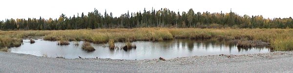 Marsh at the SE End of Beavertail Road
Mississippi River Valley Route Directions: From the SE End of Beavertail Road, return northwest 1.3 km to Richardson Side Road. Turn right or northeast onto it and go 2.5 km to turn right or southeast into our next site, David Manchester Road.
Return to Mississippi River Valley.
Return to Birding Ottawa Table of Contents.
|