TRAIL SOUTHEAST OF CORKERY ROAD
Spring: ** Summer: * Fall: ** Winter: *
Independent Directions to this Site: From Highway 417 (The Queensway) take exit 155 (March Road or Regional Road 49). Turn left or southwest onto March Road and follow it for 4.7 km to Corkery Road. Turn left or southeast on it and drive 5.1 km to the southeast end of Corkery Road, 0.9 km past Manion Corners, where the trail begins.
Mississippi River Valley Route Directions: From the Cody Creek at Old Almonte Road site, proceed 1.4 km northeast on the Old Almonte Road to Manion Corners and Corkery Road. Turn right or southeast onto it and go 0.9 km to its end, where the trail begins.
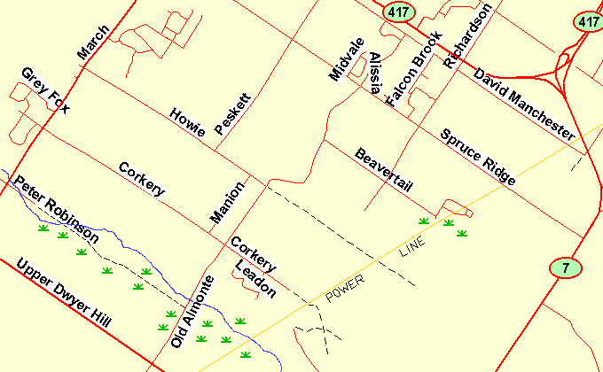 Map of the SE of Corkery Road area
Site Description and Birding Information: Beyond the end of Corkery Road is an unmaintained road leading through mixed forest. After 0.4 km it crosses a powerline right-of-way which can be followed in either direction for some distance. To the ENE the powerline can be followed for 1.6 km to reach the Trail SE of Howie Road, and 1.4 km further to the swamp near the SE end of Beavertail Road. To the WSW, it reaches Cody Creek in 1.5 km after passing some clearings around the halfway mark. These rights-of-way provide excellent viewing opportunities with good visibility, possibility of raptors crossing or following the opening and lots of edge habitat. The trail continues 0.3 km beyond the powerlines before becoming excessively wet. Pass this and reach another cross trail, providing additional variety.
Many public accesses such as this may disappear without use. Old road rights-of way, legal public access, are being closed because no one uses them. Be vigilant.
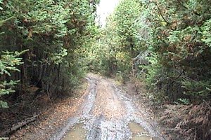 Trail SE of Corkery Road
Mississippi River Valley Route Directions: From the Trail SE of Corkery Road, return the 0.9 km along Corkery Road to Manion Corners and the Old Almonte Road. Turn right or northeast on it and drive 1.5 km to Howie Road (on the left) and our next site, the Trail SE of Howie Road (on the right).
Return to Mississippi River Valley.
Return to Birding Ottawa Table of Contents.
|