SKI HILL ROAD - MOUNT PAKENHAM
Spring: *** Summer: ** Fall: ** Winter: **
Independent Directions to this Site: From the Highway 417 (The Queensway), take Exit 169 (Kinburn Side Road) and drive southwest 5.7 km to Highway 15 in Pakenham. Turn left or SSW onto it and go 1.2 km to McWatty Road, just beyond the golf club. Turn right or southwest onto it and travel 1.3 km to Lynx Hollow Road. Turn right or northwest onto it and in 0.6 km take the left turn onto what is now Ski Hill Road to Mount Pakenham.
Mississippi River Valley Route Directions: From the bridge at Glen Creek at Pakenham Concession 9, return the 1.9 km southeast to Cedar Hill Side Road and turn left or northeast onto it and drive 0.2 km to Highway 15. Turn left onto it, actually continuing northeast, and go 4.3 km to McWatty Road, just before the golf club. Turn left or southwest onto it and travel 1.3 km to Lynx Hollow Road. Turn right or northwest onto it and in 0.6 km take the left turn onto what is now Ski Hill Road - Mount Pakenham.
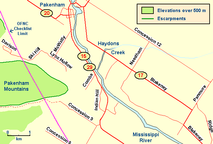 Map of the Ski Hill Road - Mount Pakenham area
Site Description and Birding Information: This site and the previous site, Glen Creek at Pakenham Concession 9, both only partly inside the circle, are just about the only spots in the checklist area where one has easy access to the Pakenham Mountains, albeit only the southeastern edge. A more northwesterly content might be expected here, especially in winter. The Black-headed Grosbeak (Nov. 21 to Dec. 28, 2003) was found along this same "edge" only 7 km to the south, just outside the circle. Feeders in this area should be scrutinized closely.
Only the first kilometre or so of Ski Hill Road is inside the circle. The ski hill and Davison Crescent are both outside. The beautiful marsh on the left or south runs along between the road and the escarpment. Watch above the escarpment for hawks and vultures soaring. Beyond the marsh, the road passes through lovely deciduous woodland. Another good spot for Indigo Bunting in summer.
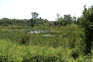 Marsh along Ski Hill Road
Mississippi River Valley Route Directions: From Ski Hill Road - Mount Pakenham, return to the righthand turn that puts you back on Lynx Hollow Road and then return the 0.6 km to McAffy Road. Turn left or northeast onto it and drive 1.3 km to Highway 15 (Lanark 29). Turn left or north onto 15 and follow it through Pakenham for a total of 3.7 km to N. Pakenham Conc. 12. Turn left to continue northwest (rather than turning northeast as Highway 15 does), and go 3.2 km to the next site on this route, the junction of Shaw Road & N. Pakenham Conc. 12.
Return to Mississippi River Valley.
Return to Birding Ottawa Table of Contents.
|