ROUTE 100 TRAIL AT NINE MILE ROAD
Spring: ** Summer: *** Fall: ** Winter: ***
Independent Directions to this Site: From Highway 417, 39 km east of Ottawa, take the Limoges exit (79) and go NNW for 4.4 km on Limoges Road (CR 5), through the town of Limoges to the junction of this road with Regional Roads 8 and 37. Follow the right hand curve on Regional 37 or the Saumure/Clarence-Cambridge Boundary Road northeast for 0.9 km to where Saumure turns left. Then continue straight northeast on the Clarence-Cambridge Boundary Road for an additional 9.6 km to Nile Mile Road (Neuf Milles Road). Turn right or SSE onto 9 Mile Road and drive 1.8 km to the Route 100 Trail at Nine Mile Road.
Larose Forest Loop Route Directions: From Skidder Road at the Clarence-Cambridge Boundary Road, return west on the Clarence-Cambridge Boundary Road for 0.2 km to Nile Mile Road (Neuf Milles Road). Turn left or SSE onto 9 Mile Road and drive 1.8 km to the Route 100 Trail at Nine Mile Road.
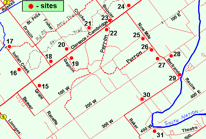 Map of the Route 100 Trail at Nine Mile Road Area
Click on other site numbers to go to their pages.
Map of the Route 100 Trail at Nine Mile Road Area
Click on other site numbers to go to their pages.
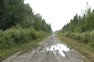
Site Description and Birding Information: Route 100, where it crosses 9 Mile Road is a dirt road/track giving access to the forested area in the central portion of the Larose Forest. In places it deteriorates into little more than a dirt track, so while it might be driven, especially with a 4-wheel drive vehicle, walking is still the best option. There is a good mix of deciduous and coniferous forest with scattered wooded swamplands along the way. The area can be quite wet in any season but winter, so boots are recommended in warmer months. Insects can be bothersome at that time too.
From this site you can go either east or west on Route 100. Nile Mile Road is the division between Route 100E and Route 100W. If you go west on Route 100W, you can make one of the loops mentioned in the Perron Road South of Clarence-Cambridge Boundary Road site. Going east on Route 100E brings you to a barricade at 1.5 km, just before reaching Tower Road (Chemin de la Tour). From there, if you wish to continue east, it is necessary to go on foot.
 Route 100E East of Tower Road
Watch along Nine Mile Road for Cape May Warblers breeding in the Black Spruce stands.
Larose Forest Loop Directions: From Route 100 Trail at Nine Mile Road, go SSE on Nine Mile Road for 0.9 km to Perron Road. Turn right or WSW onto the next site on this route, Nine Mile Road at Perron Road.
Return to Larose Forest Loop.
Return to Birding Ottawa Table of Contents.
|